


1580
Hauteur : 60 centimètre – Largeur : 48 centimètre
Numéro d'inventaire : MAP 01003
Collection : Bibliothèque nationale du pays de Galles
Localisation : Royaume-Uni
Dépeint : pays de Galles
Bibliothèque nationale du pays de Galles : https://www.library.wales


Saxton, Christopher, b.1542? | Domaine public | This image is available from the National Library of Wales You can view this image in its original context on the NLW Catalogue


1916
carte géographique - plan de sol
Matériau : encre de Chine - réplication - croquis
Hauteur : 49.8 centimètre – Largeur : 80.7 centimètre
Numéro d'inventaire : 1-06031-0000-0000
Collection : collection du Museu Paulista - Museu Paulista - João Baptista de Campos Aguirra Collection
Localisation : Museu Paulista
José Rosael/HélioNobre/Museu Paulista da USP | Domaine public | Museu Paulista
,_globo_celeste_firmato_yunus_b._al-husayn_al-asturlabi,_1144.JPG)
,_globo_celeste_firmato_yunus_b._al-husayn_al-asturlabi,_1144.JPG)

1144
Diamètre : 16.5 centimètre
Numéro d'inventaire : MAO 824
Collection : musée du Louvre - département des arts de l'Islam du musée du Louvre
Localisation : aile Denon - palais du Louvre - salle 186


1671
Hauteur : 53 centimètre – Largeur : 83 centimètre
Numéro d'inventaire : 4752
Collection : Historiehuis
Herman Jansens | Domaine public | www.voorouderslimburg.nl : Home : Info : Pic
_F.J._Nautz.jpg)
_F.J._Nautz.jpg)
1829
Collection : North Holland Archives
Dépeint : Haarlem
F.J. Nautz | Domaine public | http://www.geschiedenislokaal023.nl/bronnen/stad-in-verval-1829/


plan de la ville - plan de sol
Statut des droits d'auteur : domaine public
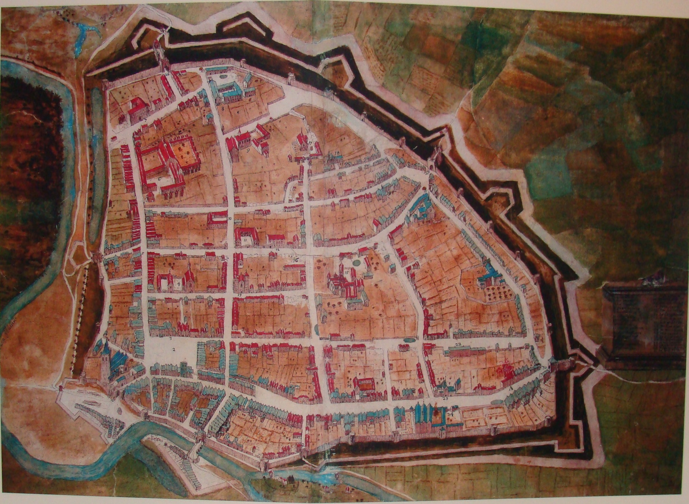
Sujet de l'œuvre : Palmanova - Palmanova Fortress
Unknown author | Domaine public | Universiteitsbibliotheek Vrije Universiteit, LL.04958gk: 148/od/1594; http://imagebase.ubvu.vu.nl/getobj.php?ppn=330024299


1588
Matériau : gouache
Numéro d'inventaire : Sloane MS 2596, f.64v
Collection : British Library - Sloane manuscripts
Partie de : The particuler description of England
Localisation : British Library
Statut des droits d'auteur : domaine public
Genre : aerial view
Sujet de l'œuvre : Cambridge
Dépeint : Cambridge
William Smith | Domaine public | This file has been provided by the British Library from its digital collections. It is also made available on a British Library website.


1588
manuscript map - pen and ink drawing
Numéro d'inventaire : Sloane MS 2596, f.16
Collection : British Library - Sloane manuscripts
Partie de : The particuler description of England
Localisation : British Library
Statut des droits d'auteur : domaine public
Genre : dessin de définition
Sujet de l'œuvre : Rochester
Dépeint : Rochester
William Smith | Domaine public | This file has been provided by the British Library from its digital collections. It is also made available on a British Library website.

Autre(s) titre(s) :
Forma Urbis Romae ; Forma Urbis Severiana ; Plan de marbre sévérien
~205
carte géographique - artéfact archéologique
Matériau : marbre
Hauteur : 13 mètre – Largeur : 18 mètre
Dépeint : Rome antique


Collection : Bibliothèque nationale du pays de Galles
Partie de : A tour in Wales
Statut des droits d'auteur : domaine public
Genre : carte géographique
Dépeint : Chester
Bibliothèque nationale du pays de Galles : https://www.library.wales
Thomas Pennant | Domaine public |


1585
Numéro d'inventaire : Harley MS 1046 f. 172
Collection : British Library
Partie de : A Treatise on the History and Antiquities of Cheshire
Localisation : British Library
Genre : bird's-eye view map
Sujet de l'œuvre : Chester
Dépeint : Chester
William Smith | Domaine public | This file has been provided by the British Library from its digital collections. It is also made available on a British Library website. - Online viewer
,_ff.71v-72_-_BL_Royal_MS_18_D_III.jpg)
individual copy of a map - épreuve
Numéro d'inventaire : Royal MS 18 D III f. 72r
Collection : British Library - BL digitised images
Partie de : Lord Burghley's Atlas
Localisation : British Library
Statut des droits d'auteur : domaine public
Sujet de l'œuvre : Northumberland
Dépeint : Northumberland
Christopher Saxton | cc0 | This file has been provided by the British Library from its digital collections. Catalogue entry: Royal MS 18 D III - Illustrated catalogue


1647
chalcographie - carte géographique
Matériau : papier
Hauteur : 54 centimètre – Largeur : 42 centimètre
Numéro d'inventaire : 1049B13_095
Collection : Bibliothèque Royale
Statut des droits d'auteur : domaine public
Genre : art figuratif
Dépeint : usine - Pernambouc
Joan Blaeu | Domaine public | This is an image from the digital and/or physical collections of the Koninklijke Bibliotheek, the Dutch National Library.


Collection : Bibliothèque nationale du pays de Galles
Partie de : A tour in Wales
Statut des droits d'auteur : domaine public
Genre : carte géographique
Dépeint : Denbigh
Bibliothèque nationale du pays de Galles : https://www.library.wales
Thomas Pennant | Domaine public |

1861
carte géographique - lithographie
Hauteur : 282 millimètre – Largeur : 425 millimètre
Numéro d'inventaire : L2007/24/14
Collection : Waikato Museum
Localisation : Waikato Museum
Statut des droits d'auteur : domaine public


The theatre of the empire of Great Britaine: presenting an exact geography of the kingdomes of England, Scotland, Ireland,... (Atlas.2.61.1)
1603
Matériau : papier
Numéro d'inventaire : Atlas 2.61.1
Collection : bibliothèque de l'université de Cambridge
Localisation : bibliothèque de l'université de Cambridge
bibliothèque de l'université de Cambridge : www.lib.cam.ac.uk
John Speed | Domaine public | http://www.lib.cam.ac.uk/deptserv/maps/unfolding/speed06.html (complete collection : http://www.lib.cam.ac.uk/deptserv/maps/speed.html)


Plan of the frederician park Sanssouci of 1772, Potsdam, Germany
1772
carte géographique - chalcographie
engraving by Johann Friedrich Schleuen, nach der Zeichnung von Friedrich Zacharias Sal(t)zmann (1731-1801) | Domaine public | 2. A. Dorgerloh: Friedrich II. und seine Gärten 1. Schlösser, Gärten, Kunstwerke, Potsdam Sanssouci 1977, Herausgegeben von der Generaldirektion der Staatlichen Schlösser und Gärten Potsdam-Sanssouci, Bearbeitet von einem Autorenkollektiv unter Leitung von Hans-Joachim Giersberg, Druckhaus Karl-Marx-Stadt, FG 041/6/77, Eingescannt von Benutzer:Nightflyer


1610
Collection : Bibliothèque nationale du pays de Galles
Dépeint : pays de Galles
Bibliothèque nationale du pays de Galles : https://www.library.wales
Speed, John, b.1552?-1629 | Domaine public |
_Abraham_Ortelius_KBS_Brafa_2019.jpg)
_Abraham_Ortelius_KBS_Brafa_2019.jpg)
Autre(s) titre(s) :
Carte d'Utopie
1595
Hauteur : 389 millimètre – Largeur : 475 millimètre
Numéro d'inventaire : KBS 0208
Collection : Fondation Roi Baudouin - musée Plantin-Moretus
Localisation : musée Plantin-Moretus
Fondation Roi Baudouin : https://www.kbs-frb.bemusée Plantin-Moretus : www.museumplantinmoretus.be
Thomas More | Domaine public | picture taken and uploaded by Paul Hermans
,_Acervo_do_Museu_Paulista_da_USP.jpg)
Agenor Machado - Georges Corbisier - Museu Paulista
,_Acervo_do_Museu_Paulista_da_USP.jpg)
Mappa Topographico do Municipio de São Paulo - Folha 12
1930
copie - illustration - carte topographique - carte géographique
Hauteur : 109.1 centimètre – Largeur : 77.05 centimètre
Numéro d'inventaire : 1-06185-0000-0000
Collection : collection du Museu Paulista - Museu Paulista - João Baptista de Campos Aguirra Collection
Localisation : Museu Paulista
José Rosael/HélioNobre/Museu Paulista da USP | Domaine public | Museu Paulista